Agro-climatic zones of India
The Food and Agriculture Organization (FAO) defines an ACZ as a land unit where the climate and growing period (LGP) are conducive to cultivating a particular set of crops and cultivars.
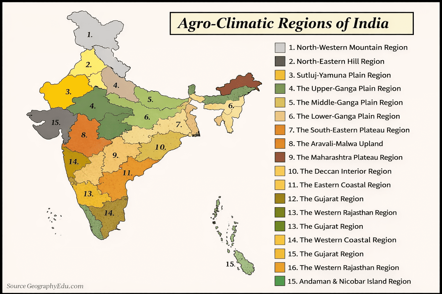
- Agro-Climatic Zones by the Planning Commission (15 Zones)
The Planning Commission of India divided the country into 15 broad agro-climatic zones as part of a macro-level agricultural planning approach. These zones were identified based on:
- Physiography: The physical geography of the region.
- Soils: Different soil types and their characteristics.
- Geological Formation: The underlying rock and mineral resources.
- Climate: Temperature, rainfall, and humidity patterns.
- Cropping Patterns: The types of crops typically grown in each region.
- Development of Irrigation: Availability and use of water resources.
- Mineral Resources: The presence of minerals that impact land use.
The objective was to integrate these agro-climatic zones with national and state plans to guide agricultural policies and ensure resource-efficient farming.
These 15 zones were further divided into 72 homogeneous sub-zones, considering local variances.
- Agro-Climatic Zones under National Agricultural Research Project (NARP) (127 Zones)
The National Agricultural Research Project (NARP) was launched by ICAR (Indian Council of Agricultural Research) to support agricultural research at the zonal level. The idea was to:
- Establish zonal research stations in each agro-climatic zone to generate location-specific, need-based research.
- Address region-specific challenges in agriculture, including natural resource limitations, cropping patterns, and socio-economic conditions.
- Create technology solutions tailored to each zone’s specific needs.
Under NARP, India was divided into 127 agro-climatic zones, providing a more detailed and focused framework for agricultural research and policy implementation.
Agro-climatic Zones of India (Based on Planning Commission)
- Western Himalayan Region:
- Region: Jammu & Kashmir, Himachal Pradesh, Uttarakhand.
- Climate: Mild summers, severe winters (avg. -4°C to 30°C).
- Rainfall: 75-150 cm; less than 30 cm in Ladakh.
- Soil: Silty loam; thin brown soils on slopes.
- Crops: Maize, wheat, potato, barley, apples, tea, saffron.
- Problems: Soil erosion, poor accessibility, landslides.
- Vegetation: Zonal arrangement along hill slopes
- This zone is having highest area (45.3%) under forests.
- Eastern Himalayan Region:
- Region: Sikkim, Assam hills, Nagaland, Manipur, Mizoram, Meghalaya, Arunachal Pradesh. (North-East states)
- Climate: Sub-humid with rugged topography. (July: 25°C-33°C, January: 11°C-24°C)
- Rainfall: 200-400 cm.
- Soil: Brownish, less fertile.
- Crops: Rice, maize, potatoes, oranges, tea oranges, pineapple, litchi
- Problems: Deforestation, soil degradation, shifting cultivation (Jhum).
- Shifting cultivation (Jhum), practiced in nearly one third of the cultivated area
- Lower Gangetic Plains Region:
- Region: West Bengal, Eastern Bihar, Assam valley.
- Climate: Hot and humid. (July: 26°C-41°C, January: 9°C-24°C)
- Rainfall: 100-200 cm.
- Soil: Alluvial (fine clay to silty clay).
- Crops: Rice (3 crops: Aus, Aman, Boro), jute, maize, tropical fruits.
- Problems: Waterlogging, small landholdings, poverty.
- This zone accounts for about 12% of the country’s rice production
- The per capita land availability here is very low (0.095 hectares) as this zone has highest density of population (692 per km2).
- Middle Gangetic Plains Region:
- Region: This zone consists of 12 districts of eastern Uttar Pradesh and 27 districts of Bihar plains Eastern U.P. has been further sub-divided into nine regions based on the heterogeneity in soil, land use, topography and climatic factors.
- Climate: Hot, humid summers; mild winters.
- Rainfall: 100-200 cm.
- Soil: Fertile alluvial.
- Crops: Rice, maize, wheat, gram, barley, mustard
- Problems: Soil erosion, waterlogging, alkaline soils.
- There is large area under salt affected (usar) lands
- Zinc deficiency in rice is wide spread.
- Upper Gangetic Plains Region:
- Region: This zone consists of 32 districts of Uttar Pradesh divided into three sub-zones of Central, North- West and South –West U.P.
- The zone has 144% cropping intensity.
- Climate: Sub-humid.
- Rainfall: 75-150 cm.
- Crops: Rice, wheat, sugarcane, pulses, mango, guava.
- Problems: Waterlogging, saline soils.
- Irrigation is largely through canals and tube wells
- Trans-Gangetic Plains Region:
- Region: Punjab, Haryana, Delhi, parts of Rajasthan.
- Climate: Semi-arid.
- Rainfall: 70-125 cm.
- Crops: Wheat, sugarcane, cotton, maize.
- Problems: Waterlogging, salinity, soil erosion.
- Highest net sown area, highest irrigated area, least poverty level, high cropping intensity (170%) and high ground water utilization.
- Rice-wheat system is prevalent.
- Eastern Plateau and Hills Region:
- Region: consists of the following sub-regions:
- I. Sub-region of Wainganga, Madhya Pradesh Eastern Hills and Orissa inland,
- II. Orissa Northern and M.P. Eastern Hills and plateau
- III. Chotanagpur North and Eastern Hills and plateau
- IV. Chotanagpur South and West Bengal Hills and Plateau, and
- V. Chattisgarh and South-Western Orissa Hills.
- Climate: Hot summers, mild winters.
- Rainfall: 80-150 cm.
- Crops: Rice, maize, millets, oilseeds.
- Problems: Nutrient-leached soils, scarce water resources.
- In kharif, 82% of the area is under rice.
- Most soils are acidic
- Central Plateau and Hills Region:
- Region: Bundelkhand, Malwa Plateau.
- Climate: Semi-arid to sub-humid.
- Rainfall: 50-100 cm.
- Crops: Cotton, soybean, pulses.
- Problems: Low water table, rocky terrain.
- The literacy percentage is low and the poverty ratio is high.
- Per capita availability of land is very high (0.446 ha).
- Western Plateau and Hills Region:
- Region: Deccan Plateau (Maharashtra). This zone comprises of major parts of Maharashtra, parts of Madhya Pradesh and one district of Rajasthan and is divided into four sub-zones
- Climate: Hot and humid.
- Rainfall: 25-75 cm.
- Crops: Jowar, cotton, oilseeds.
- Problems: Rain-shadow region, low irrigation.
- Annual average rainfall of 904 mm
- Net sown area is 65% and only 12.4% area is irrigated
- Southern Plateau and Hills Region:
- Region: Karnataka, Andhra Pradesh, Tamil Nadu.
- Climate: Semi-arid.
- Rainfall: 50-100 cm.
- Crops: Cereals, coffee, tea, spices.
- Problems: Low cropping intensity, inadequate irrigation.
- Rainfed farming is adopted in 81% of the area.
- cropping intensity is 111%.
- East Coast Plains and Hills Region:
This zone consists of six sub-zones
- Orissa coastal
- North Coastal Andhra and Ganjam,
- South Coastal Andhra,
- North Coastal Tamil Nadu,
- Thanjavur
- South Coastal Tamil Nadu.
- Region: Andhra Pradesh, Odisha.
- Climate: Sub-humid maritime.
- Rainfall: 75-150 cm.
- Crops: Rice, jute, tobacco, sugarcane. Rice and groundnut are the important crops
- Problems: Soil alkalinity, rice monoculture.
- The zone with over 2,000 km of coastline and many inland waterways is suitable for fisheries.
- Western Coastal Plains and Ghats Region:
- Region: This zone runs along the west coast, covering parts of Tamil Nadu, Kerala, Karnataka, Maharastra and Goa
- Climate: Humid.
- Rainfall: Over 200 cm.
- Crops: Rice, coconut, plantation crops.
- Problems: High rainfall erosion.
- Cropping intensity is 124%.
- This zone is important for multi-storeyed cropping.
- Gujarat Plains and Hills Region:
- Region: Kathiawar, Sabarmati basin.
- The zone is arid with low rainfall in most parts and only 22.5% of the area is irrigated, largely through wells and tube wells.
- Climate: Arid to semi-arid.
- Rainfall: 50-100 cm.
- Crops: Groundnut, cotton, oilseeds.
- Problems: Low irrigation, dry farming issues.
- it is an important oilseed zone.
- The cropping intensity is 114% and nearly 60% of the zone is considered drought prone.
- Western Dry Region:
- Region: Western Rajasthan.
- Climate: Hot, sandy desert. erratic rainfall (<25 cm), high evaporation)
- Rainfall: Less than 25 cm.
- Crops: Bajra, gram, moth beans.
- Problems: Frequent droughts, high evaporation.
- The land-man ratio is high (1.73 ha/person).
- The average annual rainfall is only 395 mm with wide fluctuations from year to year.
- The forest area is only 1.2%.
- Cropping intensity is 105%.
- The Indira Gandhi Nahar Project and DDP are the two main water sources of great potential in this zone.
- Island Region:
- Region: Andaman-Nicobar, Lakshadweep.
- Rainfall of 3,000 mm is spread over eight to nine months.
- Climate: Equatorial. heavy rainfall (<300 cm)
- Rainfall: 160-300 cm.
- Crops: Rice, maize, coconut. areca nut
- Problems: Low agricultural development.
- This is the smallest zone with a high literacy rate and low poverty levels.
Understanding these zones aids in strategic agricultural planning and resource allocation tailored to regional conditions.